File:Luwian Language de.png
Jump to navigation
Jump to search


Size of this preview: 639 × 599 pixels. Other resolutions: 256 × 240 pixels | 512 × 480 pixels | 790 × 741 pixels.
Original file (790 × 741 pixels, file size: 162 KB, MIME type: image/png)
Captions
Captions
Add a one-line explanation of what this file represents

|
File:Luwian Language de.svg is a vector version of this file. It should be used in place of this PNG file when not inferior.
File:Luwian Language de.png → File:Luwian Language de.svg
For more information, see Help:SVG. |
 |
| Description |
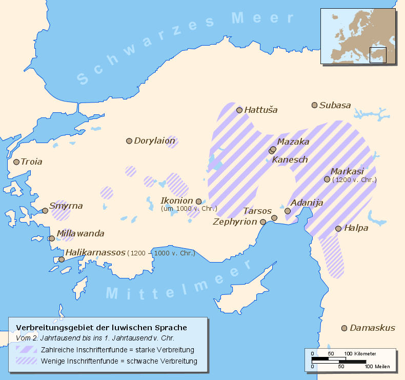
English: Map of a part of Eastern Europe/Asia with spreading of the Luwian Language
Deutsch: Karte mit Teilen Ost-Europas/Asiens mit dem Verbreitungsgebiet der luwischen Sprache |
| Date | 13 January 2007 |
| Source |
Drawn by myself, based on different source maps: Continental outlines (by San Jose), Luwian Language spreading (by Enlil2), Cities, Locator map Enlil2 extracted the data from the book “The Luwians” (H. Craig Melchert, Brill 2003) |
| Author | Hendrik Tammen (Enricopedia ⇄) |
| Permission (Reusing this file) |
Author |
| Other versions |
|

English: German translation of the city-names Deutsch: Übersetzung der Städtenamen
| ||
|---|---|---|
English: Ancient name Deutsch: Altertümlicher Name |
English: First settlements / City founded Deutsch: Erste Besiedlung / Stadtgründung |
English: Modern German name Deutsch: Heutiger Name
|
| Adanija | founded by Hittites | Adana |
| Damaskus | first settlements 5000 BC | Damaskus |
| Dorylaion (gr.) | founded by Hittites | Eskişehir |
| Halikarnassos (gr.) | founded 1200 – 1000 BC by Dorian Greeks | Bodrum |
| Halpa | first settlements 1900 BC | Aleppo |
| Hattuša | first settlements 6000 BC | Hattuša |
| Ikonion (gr.) | founded about 1000 BC | Konya |
| Kanesch | founded 1900 BC by Hittites | Kanesch |
| Markasi | founded 1200 BC | Kahramanmaras |
| Mazaka | founded by Hittites | Kayseri |
| Millawanda | founded about 3300 BC | Milet |
| Smyrna (gr.) | first settlements 10000 – 8000 BC | İzmir |
| Subasa | first settlements 7000 – 5000 BC | Sivas |
| Tarsos (gr.) | first settlements 4000 BC | Tarsus (lat.) |
| Troia / Τροία (gr.) | first settlements 3000 BC | Troja |
| Zephyrion (gr.) | founded 1500 – 1400 BC | Mersin |
| This file is licensed under the Creative Commons Attribution 2.5 Generic license. | ||
|

|
This map has been made or improved in the German Kartenwerkstatt (Map Lab). You can propose maps to improve as well.
|
File history
Click on a date/time to view the file as it appeared at that time.
| Date/Time | Thumbnail | Dimensions | User | Comment | |
|---|---|---|---|---|---|
| current | 17:23, 13 January 2007 | | 790 × 741 (162 KB) | Enricopedia (talk | contribs) | typo fix |
| 12:52, 13 January 2007 |  | 790 × 741 (163 KB) | Enricopedia (talk | contribs) | {{Information |Description={{en|Map of a part of Eastern Europe/Asia with spreading of the Luwian Language}} {{de|Karte mit Teilen Ost-Europas/Asiens mit dem Verbreitungsgebiet der luwischen Sprache}} |Source=Drawn |
You cannot overwrite this file.
File usage on Commons
The following 2 pages use this file:
File usage on other wikis
The following other wikis use this file:
- Usage on ka.wikipedia.org
- Usage on ru.wikipedia.org