File:Artsakh relief location map.jpg
Jump to navigation
Jump to search
 This JPG graphic was created with Inkscape .


Size of this preview: 521 × 599 pixels. Other resolutions: 209 × 240 pixels | 417 × 480 pixels | 700 × 805 pixels.
Original file (700 × 805 pixels, file size: 377 KB, MIME type: image/jpeg)
Captions
Captions
Add a one-line explanation of what this file represents
This file requires updating. In doing so, you could add a timestamp to the file.
|
Summary[edit]
| Description |
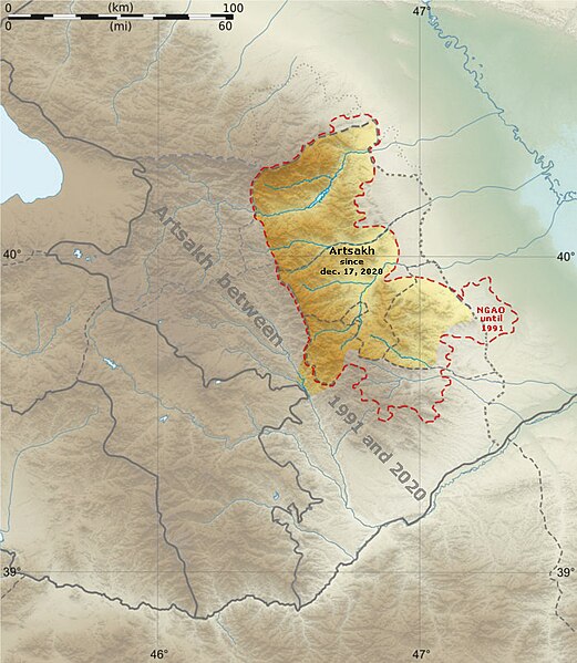
Français : Carte topographique vierge du Haut-Karabakh, avec les frontières de facto, destinée à la géolocalisation. Deutsch: Positionkarte von Bergkarabach English: Topographic blank map of Nagorno-Karabakh (de facto situation) Español: Mapa topográfico de Nagorno Karabaj Italiano: Carta topografica de Nagorno-Karabakh 日本語: ナゴルノ・カラバフの地図 Português: Carta topográfica do Nagorno-Karabakh
|
||
| Date | 4 August 2011 | ||
| Source |
Création personnelle ;
Visualization software 3DEM : patch des lacunes des srtm3 ;
Inkscape : vectorisation, intégration du fichier svg d'Openstreetmap (frontières). |
||
| Author | Bourrichon - fr:Bourrichon | ||
| Permission (Reusing this file) |
|
||
| Other versions |
Add-a-map : Template:Other versions/Nagorno-Karabakh map
|


Licensing[edit]
I, the copyright holder of this work, hereby publish it under the following licenses:

|
Permission is granted to copy, distribute and/or modify this document under the terms of the GNU Free Documentation License, Version 1.2 or any later version published by the Free Software Foundation; with no Invariant Sections, no Front-Cover Texts, and no Back-Cover Texts. A copy of the license is included in the section entitled GNU Free Documentation License. |
|
This file is licensed under the Creative Commons Attribution-Share Alike 3.0 Unported, 2.5 Generic, 2.0 Generic and 1.0 Generic license. | |
|
You may select the license of your choice.
File history
Click on a date/time to view the file as it appeared at that time.
| Date/Time | Thumbnail | Dimensions | User | Comment | |
|---|---|---|---|---|---|
| current | 19:30, 17 June 2021 | | 700 × 805 (377 KB) | Claude Zygiel (talk | contribs) | Updated |
| 22:36, 4 August 2011 |  | 700 × 805 (109 KB) | Bourrichon (talk | contribs) | == {{int:filedesc}} == {{Information |Description= {{fr|Carte topographique vierge du fr:Haut-Karabakh, avec les frontières ''de fecto'', destinée à la géolocalisation.}}{{de|Positionkarte von de:Bergkarabach}}{{en|Topographic blank map |
You cannot overwrite this file.
File usage on Commons
The following 10 pages use this file:
File usage on other wikis
The following other wikis use this file:
- Usage on be.wikipedia.org
- Usage on bg.wikipedia.org
- Usage on es.wikipedia.org
- Usage on fa.wikipedia.org
- Usage on fr.wikipedia.org
- Massacre de Khodjaly
- Stepanakert
- Khodjaly
- Chouchi
- Projet:Cartographie/Géolocalisation/Maintenance/Images des pays
- Réservoir de Sarsang
- Modèle:Géolocalisation/République du Haut-Karabagh
- Martakert
- Askeran
- Berdzor
- Martouni (Haut-Karabagh)
- Modèle:Infobox Communauté du Haut-Karabagh
- Modèle:Infobox Communauté du Haut-Karabagh/Documentation
- Aknaghbyur (Askeran)
- Aranzamin
- Astkhashen
- Aygestan (Askeran)
- Badara (Haut-Karabagh)
- Berkadzor
- Dagrav
- Dagraz
- Dashushen
- Dəmirçilər
- Harav
- Hilis
- Karmirgyugh (Askeran)
- Khatchen (village)
- Khachmach
- Khanabad (Haut-Karabagh)
- Khantsk
- Khnatsakh (Askeran)
- Khndzristan
- Khramort
- Krasni
- Kyatuk
- Lusadzor (Askeran)
- Madatashen
- Mkhitarishen
- Nakhidzhevanik
- Nerkin Sznek
- Noragyukh
- Ovsepavan
- Parukh
View more global usage of this file.