File:2012 Ghanaian General Election Map.png
Jump to navigation
Jump to search


No higher resolution available.
2012_Ghanaian_General_Election_Map.png (430 × 600 pixels, file size: 70 KB, MIME type: image/png)
Captions
Captions
Add a one-line explanation of what this file represents
Summary[edit]
Look also: User:Berkaysnklf/Elections
 This PNG graphic was created with Inkscape .
This vector image was also created with PhotoScape.
This vector image was also created with PhotoScape.
| Description |
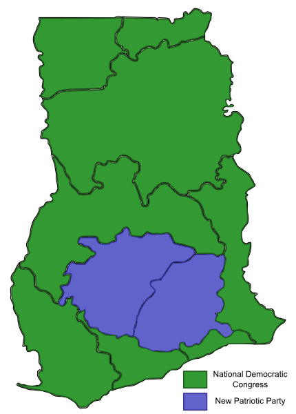
English: Map, showing the results of the Ghanaian General Election, 2012 by Regions of Ghana.
Attribution for the Borderlands of Ghana map: Thfc. |
||||||
| Date | 25 December 2012, 20:23:44 | ||||||
| Source | Own work | ||||||
| Author |
|
||||||
| Permission (Reusing this file) |
|
||||||
| Other versions |
|

Licensing[edit]
I, the copyright holder of this work, hereby publish it under the following license:
|
This file is licensed under the Creative Commons Attribution-Share Alike 3.0 Unported license. | |
|
File history
Click on a date/time to view the file as it appeared at that time.
| Date/Time | Thumbnail | Dimensions | User | Comment | |
|---|---|---|---|---|---|
| current | 18:45, 25 December 2012 | | 430 × 600 (70 KB) | BRKY24 (talk | contribs) | Some white parts have been colored and some pixel problems have been fixed. All good. |
| 18:33, 25 December 2012 |  | 430 × 600 (70 KB) | BRKY24 (talk | contribs) | User created page with UploadWizard |
You cannot overwrite this file.
File usage on Commons
The following page uses this file:
File usage on other wikis
The following other wikis use this file:
- Usage on en.wikipedia.org
- Usage on ru.wikipedia.org
- Usage on www.wikidata.org